Building massing and programming made easy

Involve more people in the planning process without expert software experience

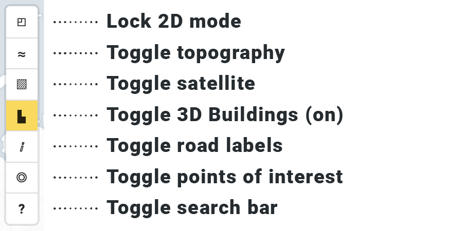
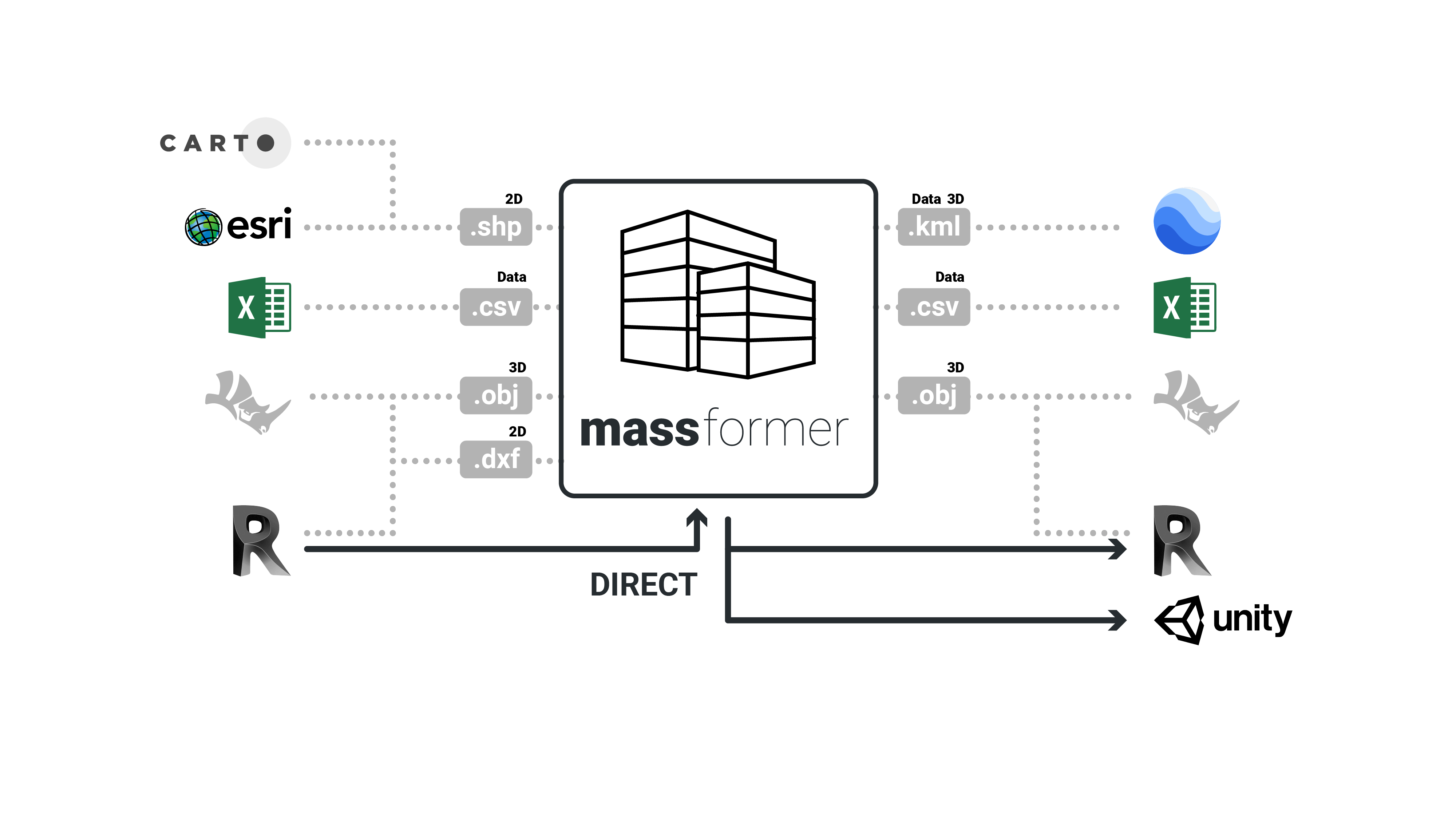
Start with rich open data sources and satellite imagery for contextual analysis

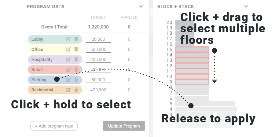
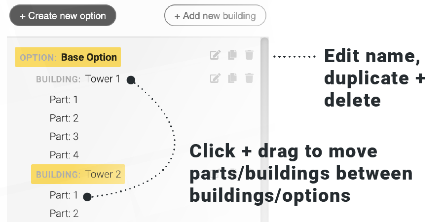
Flexible canvas to quickly develop and share multiple site concepts and options

This service aims to re-imagine the traditional process of pre-design planning and building massing with an easy-to-learn interface and toolkit to allow anyone to explore and model a development project. It uses basic “massing” blocks drawn directly on the site location in a mapping environment with the ability to introduce various types of program uses and apply them to the building. Merging and stacking geometry allows for more complex building forms and it is easy to develop multiple options with different combinations of program types, buildings and sites.

*must have received separate credentials or be a Perkins+Will employee

HOW IT WORKS

Step 1

Find your site

Just select a site by navigating the map or typing in your address or general location. Left click+drag to pan, right click+drag to orbit. There are lots of map visibility options to explore.

Step 2

Modify surroundings

Once you “arrive” you can update and modify the buildings around your site to reflect the actual conditions. Shift+click and drag to select multiple buildings.

Step 3

Draw!

Drop points on the map to draw your massing elements. Once you finish drawing you can specify the number of floors in the mass. A building can have multiple masses which can intersect and stack. 

Step 4

Program your building(s)

Generate fast and flexible program tables (information about the uses and areas of each building). Easily apply program to the floor areas of your buildings and masses.

Step 5

Create multiple options

Quickly generate multiple options; each option can have different combinations of program elements, buildings and masses.

WHAT'S MORE

1. Tips + Tricks

Edit vertices

With a shape selected click individual vertex points to move and delete. Clicking on the smaller point midway between vertices will create a new vertex point. Shift+click allows the selection of multiple vertices for moving or deleting.

Multiple programs on a floor

To allow different program elements on the same floor draw separate boundaries for each part. Overlapping parts will auto-merge, separate parts will allow different program types to be applied separately (handy for ground floors in particular).

2. Potential interoperability

With a data driven approach it is possible to ingest and export many different data formats from most common software. It is also possible to connect directly to certain software packages for direct back-and-forth.

WHAT'S NEXT

Features under consideration

Drag and drop import from .csv for program table data

Ability to select existing buildings and add them to the building set

Program editing – custom color selection and formula-driven calculation based on units / area of other program types

Add notes to locations on project site with text and images

Floor by floor editing of footprints and sub regions to allow for more granular programming

Splitting line to allow for easy sub-division of drawn shapes into smaller regions

Site line drawing tool with the ability to define offsets by side of property

Program costs per square unit and lease rate inputs for basic financial modeling of massed schemes

Time element to allow for phasing within options and to support advanced modeling

*must have received separate credentials or be a Perkins+Will employee